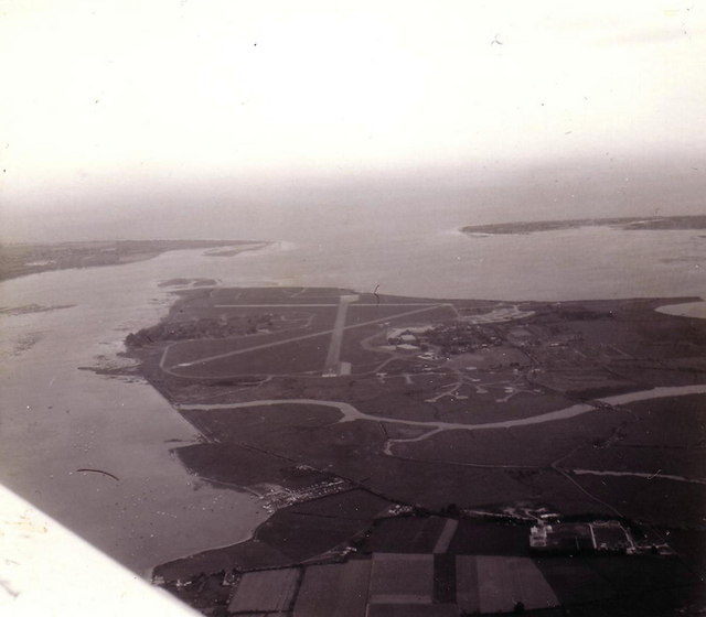
RAF Thorney Island
ⓘ licence & credit
Stephen Williams / CC BY-SA 2.0, via Wikimedia Commons — https://commons.wikimedia.org/wiki/File:Thorney_Island_airfield_from_the_air,_May_1976_-_geograph.org.uk_-_345384.jpgAbout
RAF Thorney Island occupied a low peninsula on the Sussex–Hampshire border and opened in 1938. As a Coastal Command station its Bristol Beauforts and Beaufighters flew anti-shipping strikes over the Channel — and the airfield was bombed in the Battle of Britain — before it became a fighter base of the Second Tactical Air Force, flying Hawker Typhoons and de Havilland Mosquitoes around D-Day, and later an air-sea rescue station. The RAF left in 1976, and the site is now Baker Barracks, home to the Royal Artillery.
Sources: This page was compiled from publicly available historical sources, including RAF Thorney Island — Wikipedia and Thorney Island — Airfields of Britain Conservation Trust. The text is original and has been written from factual source material; no source text has been copied unless specifically quoted and attributed.
Photographs
ⓘ licence & credit
T. W. White / CC BY-SA 3.0, via Wikimedia Commons — https://commons.wikimedia.org/wiki/File:DeHavilland_Mosquito_1944-45.JPGView source & full licence →ⓘ licence & credit
Bridge B (F/O), Royal Air Force official photographer / Public domain, via Wikimedia Commons — https://commons.wikimedia.org/wiki/File:Aircraft_of_the_Royal_Air_Force_1939-1945-_Hawker_Typhoon._CH13344.jpgView source & full licence →ⓘ licence & credit
Ministry of Aircraft Production (MAP) / Public domain, via Wikimedia Commons — https://commons.wikimedia.org/wiki/File:489_Squadron_RAF_Hampden_Jul_1942_IWM_ATP_10928B.jpgView source & full licence →ⓘ licence & credit
not stated. Assumed Royal Air Force / Public domain, via Wikimedia Commons — https://commons.wikimedia.org/wiki/File:487_Squadron_RNZAF_Mosquito_aircrew_debriefing_IWM_HU_81289.jpgView source & full licence →ⓘ licence & credit
No 1 Photographic Reconnaissance Unit / Public domain, via Wikimedia Commons — https://commons.wikimedia.org/wiki/File:RAF_Thorney_Island_aerial_photograph_WWII_IWM_HU_92962.jpgView source & full licence →No people are cross-referenced to this airfield yet. Links appear as squadron postings, crews and service records are added.